
Shiretoko National Park
Hokkaido, Japan
Why visit Shiretoko National Park?
Shiretoko National Park (知床国立公園) covers the entirety of the Shiretoko Peninsula, a remote northeastern finger of Hokkaido jutting into the Sea of Okhotsk. In 2005 it was inscribed as a UNESCO World Heritage Site, recognised for its rich and largely undisturbed ecosystem — a meeting place of marine and terrestrial life, where drift ice, dense forest and brown bears coexist.
This is one of the most remote and wild corners of all Japan. The park has no sizable settlements, and the northern portion of the peninsula has no roads at all. The two gateway towns are Utoro on the western coast and Rausu on the eastern coast. The name Shiretoko comes from the Ainu sir etok, meaning "the end of the earth" — an apt description.
Peak visiting season is the short summer, when trails, shuttle buses and boat tours operate; the park is open year-round, but winter conditions are severe. Winter does bring its own draw — the Sea of Okhotsk's famous drift ice. Whenever you come, this is a place for nature first: hikers, photographers and wildlife watchers, not sightseers after towns and museums.
Planning Shiretoko National Park? Tell us your dates and we’ll tailor the trip.
Ask on WhatsAppHow do you get there?
By Plane
The nearest airport is Memanbetsu Airport (MMB) near Abashiri, the usual air gateway for the wider region. From there, travellers continue overland toward Shari and Utoro.
By Train
The nearest train station is at Shari (Shiretoko-Shari Station), from where infrequent buses — about three per day in peak season — run through Utoro to the western coast of the peninsula.
By Car / Road
A car is effectively essential for getting the most out of Shiretoko. Rausu, on the eastern side, is reachable by bus from Kushiro (about 3.5 hours) and, in summer only, by two daily buses from Utoro. The northern side of the peninsula is off-limits to vehicles of any kind, and there are no roads on the southern side past Rausu.
For all practical purposes, getting around requires your own set of wheels — bus services are limited and infrequent, especially outside peak summer. The road over the Shiretoko Pass connects the western (Utoro) and eastern (Rausu) coasts. The northern peninsula is closed to cars entirely, and the road to Kamuiwakka Falls is closed to private traffic — a shuttle bus runs there from the Shiretoko Shizen Center (¥1,180). Trails are the other way to explore, but most serious routes require overnight camping. There are no autorickshaws or ride-hailing services.
What are the things to do?
Lakes and falls
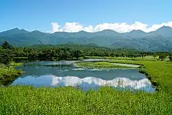
- Shiretoko Five Lakes (知床五湖 Shiretoko-goko) — The park's best-known and most accessible attraction: five lakes within walking distance, linked by well-maintained trails, with a quick circuit taking under an hour. At the end of the main western coast road; open 07:30–18:00; parking ¥400. Watch out for bears.
- Kamuiwakka Falls (カムイワッカ湯の滝) — A waterfall whose Ainu name means "river of the gods", warm from volcanic heat. Reached by shuttle bus from the Shiretoko Shizen Center (¥1,180), then a clamber up the riverbed in sturdy sandals (waraji bamboo sandals can be rented). Since 2006 only the first stretch above the bus terminal has been open, but even the lukewarm lower pool is memorable.
Viewpoints and centres
- Cape Shiretoko (知床岬) — The wild tip of the peninsula, accessible only by boat or serious hiking.
- Shiretoko Pass (知床峠) — The highest point on the cross-peninsula road, a popular stop with views of Mt. Rausu and, on a clear day, Russian-controlled Kunashiri Island.
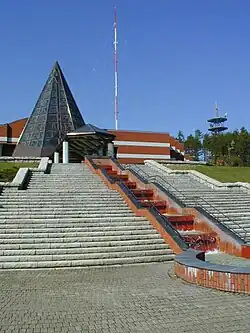
- Shiretoko World Heritage Conservation Center — The park's official visitor centre since 2009.
- Shiretoko Nature Center (Shizen Center) — A visitor and information hub on the western side.
There are several popular hikes, most requiring a night or two on the trail. The volcanically active Mt. Iō (1,563 m) is generally off-limits due to its sulphurous fumes, but Mt. Shiretoko (1,245 m) at the northern tip is a possibility.
- Mt. Rausu (羅臼岳) — A tough but popular day climb to a 1,665-m summit; dangerous in bad weather.
- Iwaobetsu Course (岩尾別コース) — The most popular and less-rugged route up Mt. Rausu, starting in the northwest.
- Rausu Onsen Course (羅臼温泉コース) — About 14.6 km round trip with a large elevation gain, taking 9–12 hours; most hikers start around 05:00. Carry water from the bottom, as some streams pass sulphurous areas.
- Iwaobetsu Onsen (岩尾別温泉) — A basic but pleasant free open-air hot spring, mixed-sex, perfect after a hard climb.
- Kuma no Yu (熊の湯) — A free 24-hour outdoor onsen across from the Rausu Onsen Campground, with a separate women's bath; bring your own towel and soap.
- Drift ice — In winter, the Sea of Okhotsk fills with pack ice off the coast, a major regional spectacle.
Planning Shiretoko National Park? Want these on a customised itinerary?
Ask on WhatsAppWhere to eat?
There are few places to eat within Shiretoko, and food stalls sometimes appear at the Shiretoko Pass.
- Kumanoya (くまのや) — In front of the Conservation Center, serving fresh seafood; open 11:00–15:00.
Hikers should bring their own food, carry out all rubbish, and avoid eating in forested areas so as not to attract bears.
Where to drink?
There are no notable bars or cafes inside the park itself — refreshments are limited to visitor centres and lodging. Carry plenty of water on hikes; stream water near sulphurous areas and steam vents may be unsafe to drink. The gateway towns of Rausu and Utoro offer more in the way of cafes and drinks.
Planning Shiretoko National Park? We’ll book the stays and dining for you.
Ask on WhatsAppWhere to stay?
Upscale lodging is found in the nearby gateway towns of Rausu and Utoro (in Shari). Within the park, camping is the main option.
- Budget / camping: Rausu Onsen Campground (羅臼温泉野営場) on Highway 344 is well placed for climbing Mt. Rausu and sits across from a free onsen; deer are often seen, so store food carefully. Rausu Nature and Green Campground, about 10 km south of central Rausu, has tent and RV sites overlooking the Pacific (tent site around ¥300).
- Mid-range / upscale: Hotels and onsen ryokan in Utoro and Rausu serve as the comfortable bases for the park.
A safety note: Shiretoko has Japan's largest brown bear (ezo-higuma) population. Attacks are very rare if you use common sense — most hikers wear tinkling bear bells, and food must never be left in or near a tent.
What should you buy?
The gift shop at the Five Lakes is the usual place to stock up on bear bells (kumasuzu) and souvenir T-shirts. The Rausu Visitor Center also sells postcards and bear bells. Shopping options are otherwise minimal — this is a wilderness park, not a retail destination.
Where to go next?
- Abashiri (west of the peninsula) — Okhotsk-coast city famed for its prison museum and winter drift-ice cruises.
- Akan-Mashu National Park (to the south) — Known for its trio of mysterious caldera lakes.
- Utoro (in Shari) — The western gateway onsen village, popular with hot spring lovers.
- Kushiro (about 3.5 hours from Rausu by bus) — Gateway to the Kushiro marshlands and red-crowned cranes.
- Memanbetsu — Site of the regional airport near Abashiri.
Nearby in Hokkaido
More places to explore around Shiretoko National Park.

Guide content as of May 2026. Portions adapted from Wikivoyage, CC BY-SA 4.0.

Contact Us
Get in touch with us.
Get in touch
Contact Us
Tell us where you'd like to go and how you like to travel. A real Tripcuro planner — not a bot — will craft an itinerary around you.
- Personalised, hassle-free planning end-to-end
- Transparent pricing, no hidden costs
- 24/7 support for complete peace of mind