
Great Australian Bight Marine Park
South Australia, Australia
About Great Australian Bight Marine Park
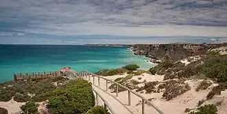
The Great Australian Bight Marine Park is a vast marine protected area off the southern coast of Australia, covering roughly 45,926 km² of Commonwealth and South Australian state waters. The marine park sits at the meeting point of the warm tropical waters flowing east from Western Australia and the cold currents of the Southern Ocean — a collision that drives extraordinary marine productivity and supports one of the most important southern right whale calving grounds on Earth. For most travellers, "visiting" the marine park really means standing on the 100-metre-high cliffs at the Head of the Bight, looking down on whales and sea lions in some of the clearest water in Australia.
The park's modern history stretches back to a series of overlapping conservation declarations: a 430 km² state whale sanctuary in 1995, a further 1,240 km² in 1996, the federal 19,395 km² addition in 1998, and finally the 2012 incorporation into the Great Australian Bight Commonwealth Marine Reserve. The South Australian portion is now overlaid by the Far West Coast Marine Park, giving the inshore waters their highest level of protection. Long before any of that, this was a Mirning sea country, and the cliffs at the Head of the Bight remain a place of deep cultural significance.
The only visitor season that really matters is the southern right whale season, roughly June through October (peak August–September), when up to a hundred whales gather in the shallow waters below the cliffs to calve and mate. Outside whale season the visitor centre still opens, but the main attraction is gone. Summer (December–February) is fiercely hot and exposed, with no shade for hundreds of kilometres along the Eyre Highway — avoid mid-day travel and carry plenty of water. There are no neighbourhoods or districts to speak of: the entire visitable footprint is the Head of the Bight precinct on the edge of Yalata Aboriginal Land.
Planning Great Australian Bight Marine Park? Tell us your dates and we’ll tailor the trip.
Ask on WhatsAppHow to reach
By Plane
There is no airport at the marine park itself. The nearest commercial airport is Ceduna (CED), about 295 km east on the Eyre Highway, served by Rex (Regional Express) with daily flights from Adelaide (around 2 hours). From Ceduna it's a 3.5-hour drive west to the Head of the Bight; you'll need a hire car, as there is no scheduled public transport along this stretch. Hertz and Budget have desks at Ceduna airport — book well ahead in whale season, as the small fleet sells out.
For travellers approaching from the west, Forrest Airport (FOS) in Western Australia is theoretically closer but is essentially a fly-in mining/charter strip with no rental cars; ignore it unless you're on a private flight.
By Train
By Car / Road
Almost everyone arrives by car or campervan along the Eyre Highway (A1), the only sealed road across the Nullarbor. The Head of the Bight turn-off is a clearly signed 20-minute deviation from the highway, on the Yalata side just east of the WA border.
Indicative driving distances and times:
- Ceduna → Head of the Bight: ~295 km, ~3.5 hours.
- Adelaide → Head of the Bight: ~1,100 km, 12–14 hours; most travellers split this over two days with an overnight in Port Augusta or Streaky Bay.
- Perth → Head of the Bight: ~1,950 km, 3 days minimum with mandatory fuel stops at Norseman, Balladonia, Caiguna, Madura, Mundrabilla, and Eucla.
Road quality is good sealed bitumen the whole way, but it is remote two-lane highway with very long fuel gaps (up to 200 km between roadhouses on the Nullarbor) and roaming livestock, kangaroos, and camels — do not drive at dawn, dusk, or after dark. Carry extra water, a spare tyre in good condition, and a paper map; mobile coverage drops out for hundreds of kilometres.
Long-distance coach: Greyhound Australia runs a Perth–Adelaide service along the Eyre Highway a few times a week and will set down on request at the Nullarbor Roadhouse, but you'd then need a pre-arranged transfer or hire vehicle for the final 80 km to the Head of the Bight — not a practical option for most.
There is no "around" to speak of on land — the visitable area is a single precinct: the visitor centre, a short access road, and the cliff-top boardwalks and viewing platforms. Everything is walkable from the car park in a few minutes.
To go any further into the marine park itself, a boat is your only option, and recreational access is restricted; most of the marine park is closed or permit-only. There are no ride-hailing services (no Uber, no taxis), no buses, and no fuel at the Head of the Bight — the nearest pumps are at the Nullarbor Roadhouse (~80 km west) and Yalata Roadhouse (~50 km east). Fill up before you turn off the highway.
There are no scams to speak of, but two practical traps: don't rely on credit cards at the small roadhouses (some are cash-only or have intermittent EFTPOS), and don't underestimate fuel range — a "we'll make it" approach has stranded plenty of travellers out here.
Things to do
Head of the Bight Whale Watching Platform — The reason you came. A series of timber boardwalks and platforms set on the edge of the Bunda Cliffs, looking straight down onto southern right whales calving in the shallows from June to October. Open daily 8AM–5PM (last entry 4PM); entry is via the visitor centre. Adult day pass approximately A$15, concession A$10, children A$6, family A$35 (rates revised seasonally — confirm at the gate). Off-season (November–May) discounted entry applies but whale sightings are not guaranteed.
Bunda Cliffs — The 100-metre limestone sea cliffs that mark the southern edge of the Nullarbor Plain stretching for around 200 km west from the Head of the Bight. Several unsigned cliff-top pull-offs along the Eyre Highway between the Head of the Bight and the WA border give vertigo-inducing views; stay well back from the unfenced edges.
Head of the Bight Visitor Centre — Compact interpretive centre with displays on the whales, the Mirning people's connection to this coast, the marine park's geology, and the Nullarbor's natural history. Address: Unnamed Road, Yalata SA 5690. Phone: +61 8 8625 6201. Hours 8AM–5PM daily during whale season.
Australian Sea Lion Colony viewing — Sea lions haul out on the rocky shelves below the cliffs and were historically very hard to spot from above; since drone monitoring began in 2017 they're more reliably located, and rangers at the visitor centre can point out current haul-out spots.
Mirning rock art and cultural sites — The surrounding Yalata Aboriginal Land contains significant Mirning cultural sites; access is restricted and only available with permission or via guided arrangement through the Yalata community.
Whale watching from the cliffs (June–October) — The single defining experience. Bring binoculars; mid-morning light is best for spotting cow-and-calf pairs against the pale sandy seabed. A solid 1–2 hours on the platforms is rewarding.
Stargazing — The Nullarbor has some of the darkest skies in Australia. On a moonless night the Milky Way is overwhelming; the cliff-top car parks (when open) and pull-offs along the Eyre Highway are excellent informal viewing spots.
Permit-based marine activities — Diving, fishing, and any extractive or research activity inside the marine park requires a permit; applications are made through the Australian Government's environment portal at environment.gov.au. Rough water, strong currents, and great white sharks make recreational diving here a serious undertaking, not a casual one.
Drive the Nullarbor as an experience in itself — Cross the WA/SA border at Border Village, count the "Treeless Plain" signs, and add your sticker to the road-train cabs at Eucla. The crossing is the trip for many travellers; the marine park is the highlight along the way.
Photography along the Bunda Cliffs — Late-afternoon light onto the white limestone face is spectacular; safe shooting positions exist at the formal lookouts inside the Head of the Bight precinct.
Planning Great Australian Bight Marine Park? Want these on a customised itinerary?
Ask on WhatsAppFood & Dining
Food at the Head of the Bight itself is limited to a small café/kiosk inside the visitor centre serving coffee, pies, sandwiches, cold drinks, and ice creams during opening hours. There are no restaurants, no picnic facilities to speak of, and no campfires permitted inside the precinct. Most travellers self-cater from supplies brought from Ceduna or Norseman.
The closest sit-down meals are at the surrounding roadhouses, where the menu is reliably "Aussie roadhouse" — burgers, schnitzels, fish and chips, hot breakfasts:
- Nullarbor Roadhouse Restaurant (~80 km west, on the Eyre Highway) — Open long hours (typically 6:30AM–9PM). Hot mains around A$25–35, burgers around A$18–22. Reasonable veg options (veggie burger, chips, salads); halal/gluten-free not reliably catered.
- Yalata Roadhouse (~50 km east) — Basic takeaway counter; hours can be limited, opening days vary; check before relying on it.
- Border Village Roadhouse (at the SA/WA border, ~190 km west) — Roadhouse meals plus the famous "Rooey II" big-kangaroo photo stop. Mains A$20–30.
- Penong Hotel (Penong, ~220 km east) — A proper country pub with counter meals; chicken parmies, steaks, and pints in the A$25–35 range.
- Ceduna Foreshore Hotel Motel (Ceduna, ~295 km east) — Best sit-down option within reasonable driving range; specialises in Ceduna oysters straight off the local leases (a dozen natural around A$25–30) and seafood platters; mains A$30–45.
Cafes & Nightlife
There is no licensed bar at the Head of the Bight; the visitor centre kiosk sells only soft drinks, water, juices, and coffee. Note that Yalata is an Aboriginal land covered by alcohol restrictions — do not bring or transit alcohol through the community without checking current rules; signage on the Eyre Highway sets out the conditions.
For a drink with your dinner, the Nullarbor Roadhouse bar, Border Village Roadhouse, Penong Hotel, and the various pubs in Ceduna (the Ceduna Foreshore Hotel and the Ceduna Community Hotel/Motel) are your nearest options; standard Australian pub beer pricing, around A$8–12 a pint.
Tap water is safe to drink at all roadhouses and at the visitor centre, but supplies are precious and often rainwater-tank or trucked-in — don't waste it. Always carry several litres of bottled water per person in the vehicle as a basic safety measure on the Nullarbor.
Planning Great Australian Bight Marine Park? We’ll book the stays and dining for you.
Ask on WhatsAppPlaces to Stay
There is no accommodation inside the marine park — no campground, no cabins, no lodge. The closest beds are at the Nullarbor Roadhouse and Yalata Roadhouse; for anything more comfortable you're looking at Ceduna.
Budget
- Nullarbor Roadhouse Caravan Park (Eyre Highway, ~80 km west of the Head of the Bight) — Unpowered tent sites around A$25–30 per site, powered sites A$40–50, basic budget rooms from around A$110. The closest place to sleep to the marine park.
- Yalata Roadhouse campground (~50 km east) — Very basic powered/unpowered sites, around A$25–35; check current operating status before relying on it.
Mid-range
- Nullarbor Roadhouse Motel (Eyre Highway) — Standard motel rooms from around A$160–200 twin/double; the only real "motel" at the western end. Books out solidly in whale season — reserve weeks ahead.
- Ceduna Foreshore Hotel Motel (32 O'Loughlin Terrace, Ceduna) — Comfortable waterfront motel rooms from around A$180–230, attached restaurant and bar.
Upscale / heritage
What to buy
There is essentially nothing to buy on site beyond entry tickets, a small range of souvenirs (postcards, books, locally produced crafts), cold drinks, and snacks at the Head of the Bight Visitor Centre. The neighbouring Yalata Aboriginal community sometimes sells locally made artefacts and paintings — the visitor centre can advise on what's currently available.
For real shopping, the nearest towns are Ceduna (groceries at Foodland and IGA, fuel, pharmacy, takeaway food) 295 km east and Eucla / Border Village (limited roadhouse goods) west of the SA border. Stock up on food, water, and any vehicle supplies in Ceduna or Penong before heading west — prices climb steeply at every roadhouse the further you get into the Nullarbor, and selection is minimal. Bargaining is not a thing in Australia.
Go next
- Nullarbor Wilderness Protection Area — Immediately inland to the north; vast treeless plain, blowholes, and the Murrawijinie Caves. Accessible from the Nullarbor Roadhouse.
- Eucla and the Border Village (~190 km west) — The old telegraph station ruins half-buried in dunes, plus the symbolic SA/WA border crossing; the gateway to Western Australia's stretch of the Nullarbor.
- Ceduna (~295 km east, ~3.5 hours) — Oyster capital, regional service hub, jumping-off point for the Eyre Peninsula's west coast.
- Streaky Bay (~480 km east, ~5.5 hours) — Pretty fishing town with sheltered swimming, sea-lion-frequented beaches, and the wave-cut Murphy's Haystacks granite formations nearby.
- Coffin Bay (~700 km east) — Famous for its oysters and the rugged Coffin Bay National Park; an easy add-on if you're continuing down the Eyre Peninsula.
- Esperance (Western Australia, ~1,150 km west) — White-sand beaches at Lucky Bay and Cape Le Grand National Park; a long but extraordinary drive across the rest of the Nullarbor.
Nearby in South Australia
More places to explore around Great Australian Bight Marine Park.
Portions adapted from Wikivoyage, CC BY-SA 4.0.

Contact Us
Get in touch with us.
Get in touch
Contact Us
Tell us where you'd like to go and how you like to travel. A real Tripcuro planner — not a bot — will craft an itinerary around you.
- Personalised, hassle-free planning end-to-end
- Transparent pricing, no hidden costs
- 24/7 support for complete peace of mind